On clear days, most visitors will head straight to the state park’s 3,849-foot summit to capture panoramas of the San Francisco Golden Gate Bridge to the west, the Santa Cruz Mountains to the south, Mount Saint Helena to the north, and even the crest of the Sierra Nevadas to the east. In total, it’s possible to see over 8,500 square miles and 40 California counties from the summit.
Things to Do
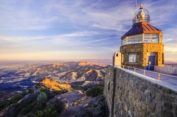
Although California certainly contains much higher mountains, Mount Diablo’s combination of rolling hills and flat valleys make the views here completely unique. The Summit Visitor Center is open daily from 10 a.m. to 4 p.m. in a tower constructed from sandstone blocks (complete with a few ancient marine fossils embedded inside) in the 1930s, and it’s the best place to start for first-timers to the park. Here’s where visitors get information about hiking trails or the historical and cultural aspects of Mount Diablo with several exhibits, artworks, and staff on hand to answer questions.
Next, walk up the circular stairway to the observation deck to check out the iconic views before heading back down to explore “Rock City” about one mile north of the south gate. Great for kids, this portion of the park has large sandstone rock formations and wind-hollowed caves to climb around (safely, of course). Make sure to take some time to observe the Native American grinding rocks and one of the larger boulders that’s been dubbed “Sentinel Rock,” climbable thanks to carved steps and installed railings.
In the springtime, make a stop on the north side of the mountain at the Mitchell Canyon area, which is famous for its wildflowers. If you still haven’t had enough of the views, there’s another overlook near the Juniper Campground to catch a stunning glimpse of the Golden Gate Bridge.
Best Hikes & Trails
Mount Diablo State Park encompasses more than 20,000 acres, so there is plenty of space to explore. Pick up free maps and brochures with suggested hikes at the Summit Visitors Center to get a better idea of the trails available inside the park.
Eagle Peak: One of the most popular trails in the park, Eagle Peak is a 7-mile difficult hike offering rewarding views at the top. During the spring, this trail is known for its wildflowers and is popular with runners who are looking for a serious workout. Start on Mitchell Canyon Fire Road before turning left onto the Eagle Peak Trail. After about 2 miles and 1,000 feet in elevation, you reach Twin Peaks first. A bit farther, the Mitchell Rock Trail ends at the Eagle Peak Trail and climbs to the summit of Eagle Peak, about 1,800 feet above where you started.
Mount Diablo Summit from Mitchell Canyon: If you’d rather hike than drive to the summit, you can continue past Eagle Peak to complete the 13 mile trail to the top of Mount Diablo. Once you’ve reached Eagle Peak, head down the North Peak Trail towards the Summit Trail and you’ll reach the visitor center after a strenuous climb.
Mary Bowerman Interpretive Trail: Previously known as the Fire Interpretive Trail, this hike starts about 500 feet downhill from the summit parking lot. Grab a pamphlet that accompanies this hike at the visitors center (it will help you identify some of the plants and birds you’ll be seeing) before setting out on the easy 0.7-mile path. The first portion of the interpretive trail to the Ransom Point overlook is paved and wheelchair-accessible, as well.
Donner Creek Loop Trail: This moderate, 5.2-mile loop hike features waterfalls and is open to horseback riding. Find the trailhead at the end of Regency Drive and follow Donner Canyon Road until turning left at Cardinet Oaks Road. Cross the creek and follow the service road to a signed turnoff on the right and follow it into the canyon.
Where to Camp
There are three campgrounds available at Mount Diablo State Park, as well as a group site and a group horse campground for equestrians. All campgrounds have access to drinking water and flush toilets while each site comes with a table, fire ring, and grill. Visitors can reserve campsites through Reserve California up to six months in advance. Due to its high altitude, it can get pretty cold and windy if you’re camping overnight, so be sure to bring plenty of layers (even in the summer).
Live Oak Campground: About one mile from the South Gate Entrance, Live Oak has two sites available at $30 per night. It has the lowest elevation of each of the other campgrounds and is located nearest to the rock formations at “Rock City.”
Junction Campground: The six sites here are first-come, first-served only, so get here early if you want to nab a spot. It is located where South Gate Road and North Gate Road meet and is situated in a peaceful open woodland area. $30 per night.
Juniper Campground: The only campground in the park with showers, the 31-site Juniper Campground is the most popular in the park. At 3,000 feet, it’s the highest-elevated campground, so it also offers the best views. $30 per night.
Group Campgrounds: There are five tent-only group campsites available, each with a capacity of between 20 and 50 people. Sites range from $65 to $165 per night depending on vehicle and camper capacity. Barbecue Terrace, the horse camp, is equipped with horse ties for equestrian use and has a capacity of 50.
How to Get There
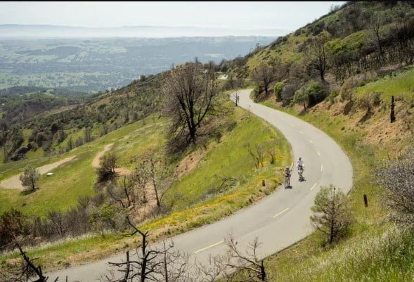
Located in the San Francisco East Bay Area in Contra Costa County, Mount Diablo State Park is one of these places where the journey can be just as beautiful as the destination. Thanks to the summit’s location about 3,800 feet up, the drive getting there is half the fun. The windy road has more than a few sharp turns and curves, and can get windy depending on the weather. It’s also a very popular route for cyclists, so be sure to watch out for bikes along the way (although there isn’t a designated bike line, they’ve built a lot of turnouts to accommodate bikers).
While the summit is just over 10 miles from the town of Walnut Creek, the twists and turns—not to mention the patience required for sharing the road with cyclists—will make the drive about 30 to 45 minutes long. Most visitors come through the North Gate Road Entrance, but you can also take the South Gate Road Entrance. Both routes provide access to the summit and require a $10 entrance fee per vehicle.
Another option is to enter through the Mitchell Canyon Staging Area or the Macedo Ranch Staging Area; parking only costs $6 here, but there is no driving access to the summit.
Accessibility
Accessible parking, ground-level entry, and an accessible restroom are available near the Visitor Center. In the past, the state park provided an elevator at the Visitor Center as well, but it has been closed indefinitely. There are three accessible campsites with accessible parking and an accessible bathroom in the Juniper Campground, and an accessible picnic area with several picnic tables and barbecues located near the lower summit parking lot. The Mitchell Canyon Interpretive Center has a ramped entry with a designated accessible parking spot located near the office, however, the surface space is covered in loose gravel.
Tips for Your Visit
Gates open 8 a.m. every morning and close at sunset, so plan on being inside your vehicle and heading out by sunset or you may get locked inside the park.
Northern California is known for its water shortages, and if you come during a drought, chances are the park has already turned off the water faucets in the picnic areas and at least some of the campground showers. They usually leave portable toilets and hand washing stations, and will have potable water available at the Junction Ranger Station. Still, it’s best to bring plenty of your own water just in case, especially during the more scorching summer months.
As always, keep a safe distance from wild animals and never touch or feed wildlife.
Watch out for poison oak; there’s a ton of it along the trails.
Keep in mind that dogs are only allowed on paved roads and campgrounds, so leave your pooch at home if you plan on spending most of your time hiking.

